Shore Excursion — Northern Lazio
Civita di Bagnoregio
- Duration
- 8–10h
- Distance
- ~220 km
- Vehicle
- Mercedes E / S / V-Class
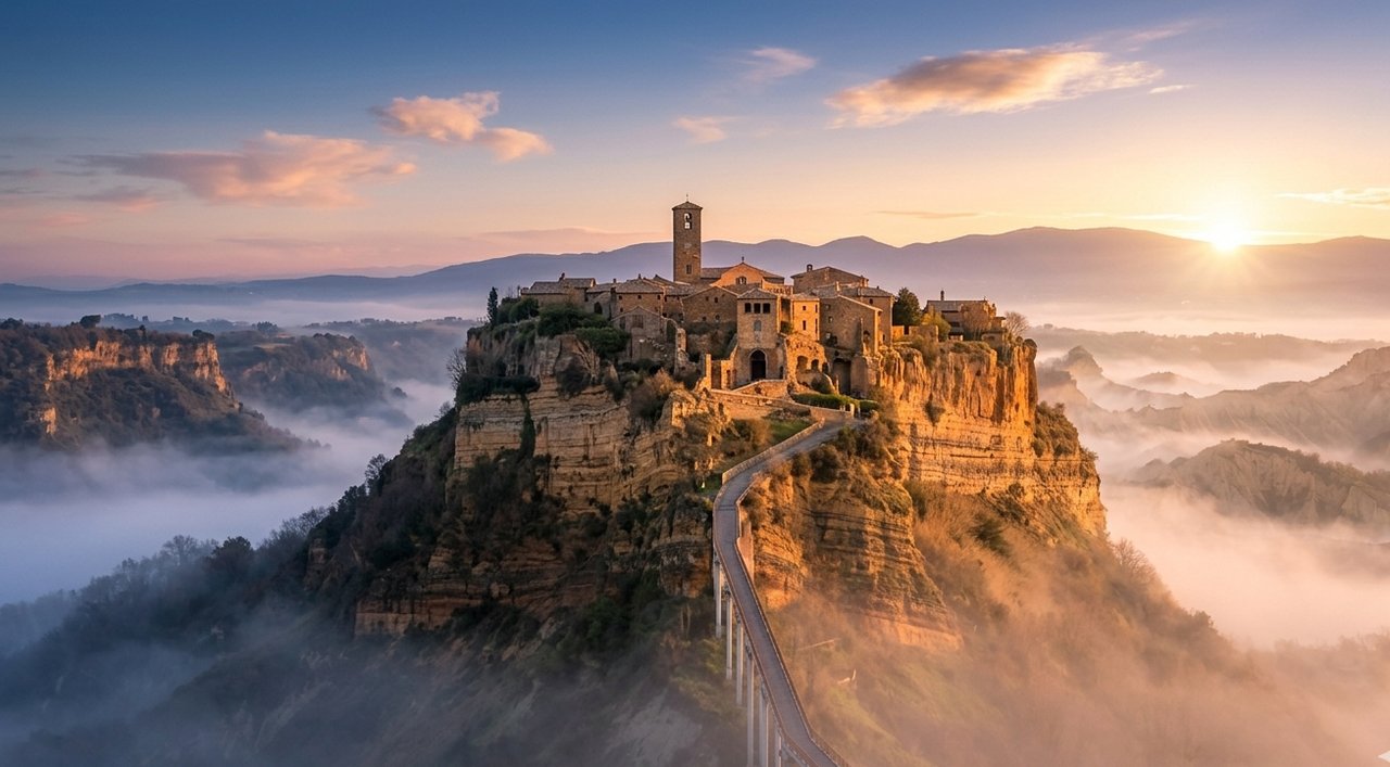
The civita di bagnoregio tour from civitavecchia follows the Via Cassia north through the volcanic landscape of northern Lazio — a world of tufa cliffs, ravines and plateau-top villages that looks nothing like the Italy of tourist brochures and everything like the Italy that existed before the brochures. Two hours north of the port, you reach the ridge above Bagnoregio and see, on the adjacent plateau, the thing that photographs have not prepared you for. Civita di Bagnoregio is not on a hill; it is on a column of eroding tufa that is surrounded on all sides by ravines. The bridge that connects it to the inhabited world is 300 metres long and, at its narrowest, barely wide enough for two people to pass.
La città che muore — the dying city — earned its name because the tufa on which it stands is being eaten away by rain, frost and wind at a rate that has been measurable since the nineteenth century. Streets that once led somewhere now end in air. The population, which numbered in the thousands in the medieval period, has dwindled to a handful of permanent residents. What remains is a single main street, a Romanesque church, a few small restaurants, caves carved into the cliff face, and a view from the far edge of the plateau — across the ravines to the hills of Umbria, with Orvieto visible on its own mesa to the north — that no other excursion from the port provides.
Request a QuoteItaly's most dramatic village — and one of the least known
-
The bridge — the approach that earns the view
The 300-metre pedestrian bridge across the ravine to Civita is part of the experience. On a clear morning, the light comes from the east and turns the tufa column golden before you have taken ten steps. There is no other approach like it in Italy.
-
The village — medieval time, extreme geography
Inside the gate, Civita has one street, one church, a handful of restaurants and a few dozen permanent residents. The Church of San Donato contains an Etruscan sarcophagus found nearby. The caves beneath the village were stables for two thousand years. The whole place fits inside a football pitch.
-
The view that justifies the drive
From the far edge of the plateau, the ravines drop away in every direction and Umbria stretches north. On clear mornings, Orvieto is visible on its own mesa. It is one of those views that prints itself on the memory immediately and permanently.
Frequently Asked Questions
How long is the drive from Civitavecchia to Civita di Bagnoregio?
Approximately two hours each way, mainly via the Via Cassia and provincial roads. The route passes through volcanic northern Lazio — the landscape is part of the journey. We recommend departing by 8 am to arrive before the day-visitors from Rome.
Is the bridge walk difficult?
The bridge is relatively level and paved, but it is 300 metres long and exposed to wind. The village itself has uneven cobblestones and some steps, but is compact — most visitors with standard mobility complete it comfortably in under an hour. Guests with significant mobility limitations should ask us for honest advice before booking.
Can I combine Civita with Orvieto or Viterbo?
Yes — Orvieto is 25 minutes from Civita and the combination makes a full and varied day. Viterbo, with its medieval Papal Palace and thermal baths, is 30 minutes south of Civita. We offer dedicated tours for the Civita-Orvieto-Lake Bolsena combination; for other combinations, describe your interests in the quote form and we will design the day.
Other private tours
Plan your private tour
Tell us your date, group size and preferred destinations. Your all-inclusive quote arrives within hours.